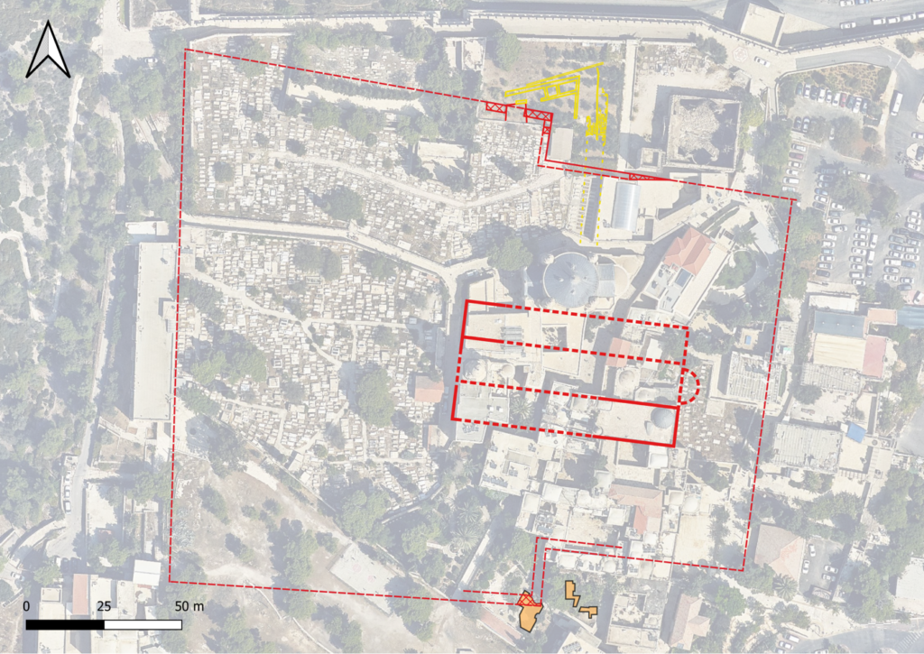
Since 2015, the GPIA Jerusalem has been exploring and excavating on Mount Zion, a strategically important hill in the city of Jerusalem located southwest of the Old City. So far, the GPIA has investigated the Anglican-Prussian cemetery, with its city gates, walls and its extensive residential area (Area I), the elevated terrace of the ‘Greek Garden’ with a Byzantine villa (Area II) and the course of the Byzantine and Ayyubid city walls at the southwestern cliff of the city area (Area III). The rescue excavations of the Israel Antiquities Authority (IAA) at ‘Šulḥan David’ (M. Chernin), the Catholic cemetery (Marion Sindel) and adjacent to it south of HaShalom Street (Y. Zelinger) complete the research of an impressive puzzle comprising of urban archaeological excavations. Based on this work, what could be more natural than for the GPIA to join forces with our colleagues from the Israel Antiquities Authority in 2021 to conduct a new excavation in the area of the Dormition Abbey garden at Bet Yosef (Area IV) and the IAA rescue excavation due to renovation work in the Dormition building?
From: D. Vieweger, K. Soennecken, J. Zimni, P. Leiverkus, M. White (all GPIA Jerusalem) and Michael Chernin (IAA) with gratitude to the monks of the Dormition Abbey for all their help and courtesy
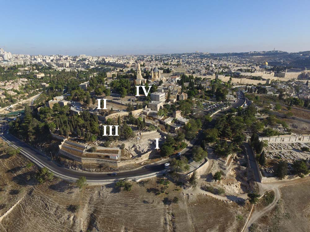
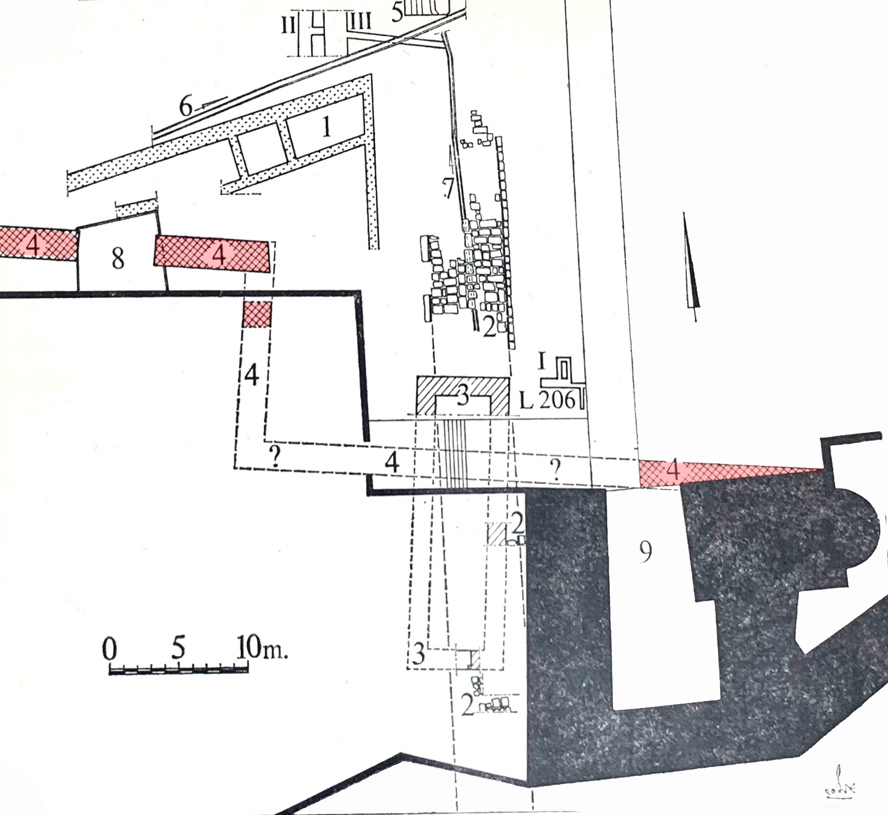
From July 4-30, 2021, GPIA, in cooperation with the Israel Antiquities Authority, conducted the first excavation season in the gardens of Dormition Abbey (Area IV). Three areas were opened. The sounding (Area IV/1) is located northeast of Bet Yosef and the intention was to expose the Ayyubid dry moat connecting to the one found in the Anglican-Prussian Cemetery (Area III) with the adjacent city wall remains. Areas IV/2 and IV/3 (both northwest of Bet Yosef) were to explore the Byzantine building. In Area IV/1, it soon became clear the marked differences in elevation to the present surroundings of Bet Yosef did not reflect the Ayyubid dry moat or even natural features but it was created by backfill from the construction work in the 20th century CE.
Presumably, the Ayyubid wall should be located further east of Bet Yosef, which was as also assumed by F. Bliss and A. Dickie at the end of the 19th century.
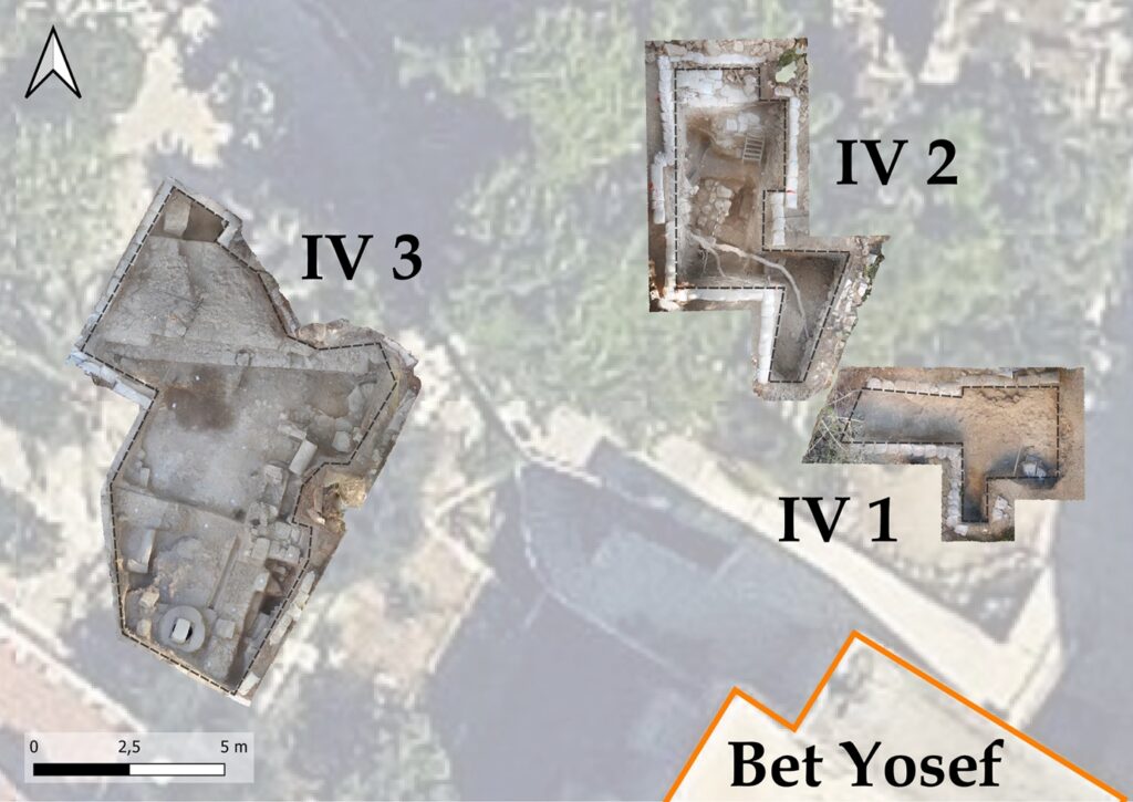
To reach the Byzantine living quarters, the excavation teams needed one week for Area IV/3 and two weeks for Area IV/2. Only after removing the 1.5 to 3.5 m of modern rubble that included finds such as plastic bottles, an American eagle from 1984, a Victorian coin from 1903 and many Ottoman pipe heads, Umayyad (638-750 CE); then the later Byzantine living areas were discovered (4-7th century CE) under a solidified lime-clay layer. In Area IV/2, the stratigraphy even reached back to the Herodian period; only pottery sherds in Area IV/3 testify to the Herodian period, while both areas had pottery sherds appearing to Iron Age II.
The Byzantine building in Area IV/3 contained a plastered room cut into the rock (possibly a former cellar), a central courtyard with a water channel and cistern, and other adjacent rooms strongly resembled the typical Byzantine residential building found within the Byzantine city gate located in the Anglican-Prussian Zion cemetery (GPIA Area I).
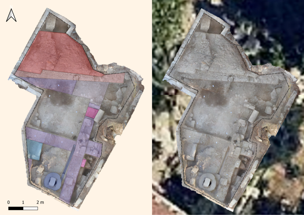
A hoard find near an inner wall of this building brought to light 16 Byzantine coins that were probably buried in the city in 614 CE before the Sassanid conquest with all its devastation and looting. The owner, after the dramatic events at the beginning of the 7th century CE, was apparently unable to recover his savings after the re-conquest of the city.
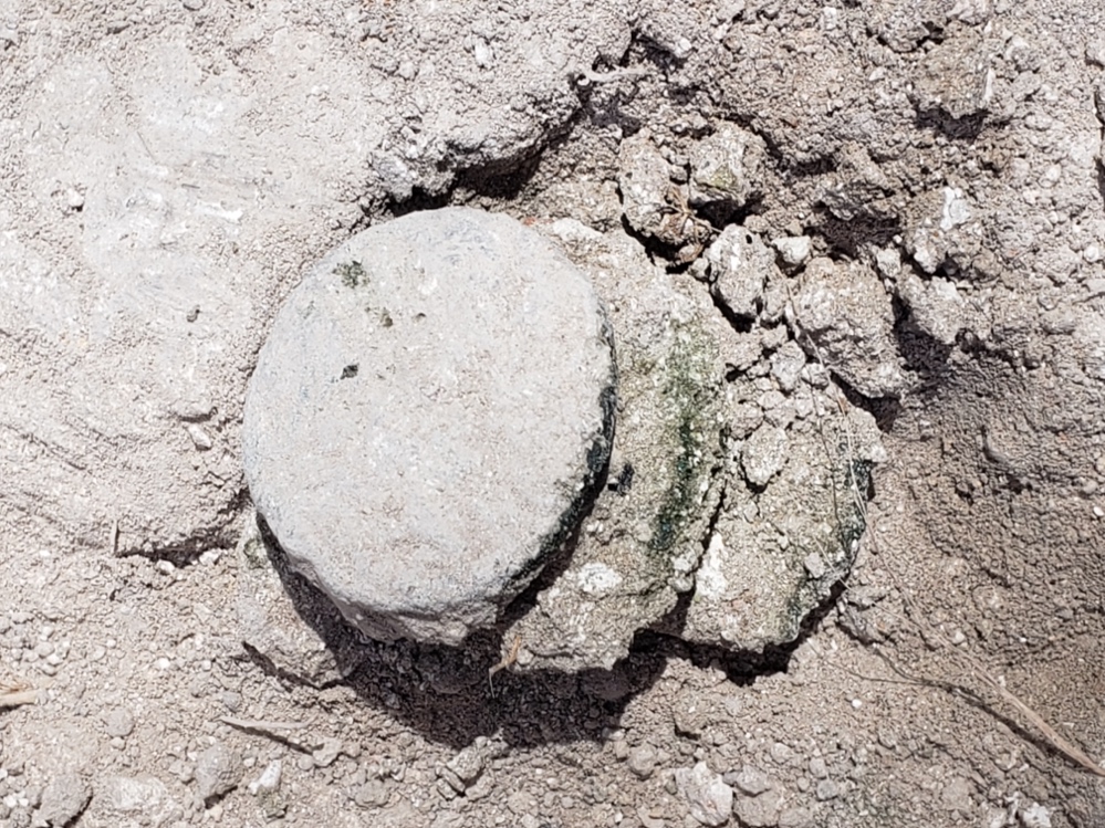
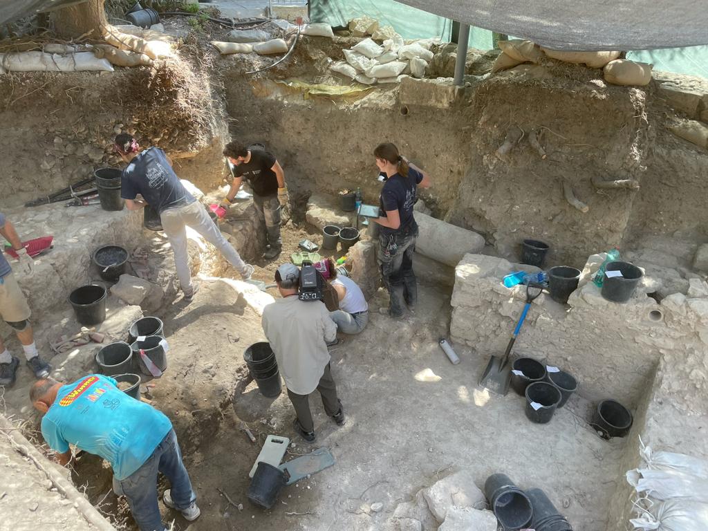
During the extension on the north side of Area IV/3, the excavators came across a huge structure, which at first sight reminded them of the worn, naturally occurring rock. However, this structure turned out to be a massive wall, 3.20 m wide, which was additionally founded on a projecting foundation on the outside.[1] The monumental construction of this wall clearly surpassed the four city walls excavated by the GPIA in recent years at the Anglican-Prussian Cemetery. [1] Possibly to protect against undermining, however, probably more to secure the foundation.
The newly discovered defensive wall in the garden of the Dormition Abbey clearly exceeded the defensive capability of the Byzantine wall from the 5th century BCE. Its height may be estimated at 6-8 m. It runs roughly parallel to the longitudinal axis of the Byzantine and Crusader churches on the top of Mount Zion. The pottery of the surrounding area points to the (High) Middle Ages.
Thanks to the friendly and knowledgeable assistance of Professors D. Pringle, H.E. Mayer, T. Wozniak, W. Zöller, A. Reʿem and K. Bieberstein, it soon became very clear this was a walled enclosure for the Crusader-period church of St. Mary and the Holy Spirit as well as of the adjacent monastery (of the Canons Regular of St. Augustine’s Order). Medieval pilgrims report about such an enclosure:
Theodoricus[1], who very probably stayed in Jerusalem in 1172 CE.[2], mentions in his Itinerary (chapter 22) Mount of Zion, which in his time was located south of the city walls, and the Church of St. Mary. It had been protected with walls and towers: “Sion ergo mons, ad meridiem extra muros civitatis ex maxima parte constitutus, ecclesiam dominae nostrae sanctae Mariae articulatam, muris, turribus, propugnaculis adversus gentilium insidias valde munitam continet, in qua regulares praepositum habentes Deo deserviunt.”
John Phocas (chapter 14) also reported from his visit to Jerusalem in 1177 CE about a strong fortification on Mount Zion, where the great church, Hagia Sion, the mother of all churches, had been located.[3]
This is also confirmed by the Gesta regis Henrici Secundi Benedicti Abbatis (1169-1192),[4] which refer to the Augustinian monastery on Mount Zion as a “Castellum.”
Finally, it is necessary to refer to the map of Cambrai, which dates from the middle of the 12th century CE and depicts two other walled monasteries named also in the Gesta as castellum (on the Mount of Olives, in the Valley of Jehoshaphat [Kidron] and on Mount Zion). These three walled monasteries stand on the map as their walls (with battlements) are depicted in the foreground of several towers from the many free-standing churches.[5]
All this data coincides with the information from the Muslim geographer Muhammad al-Idrisi, who wrote before 1154 CE. In his writing he describes the church on Mount Zion by saying that it is not only magnificent, but also fortified.[6]
The history for the foundation of a wall around Mt. Zion can be taken from a falsified, however, in its core unsuspicious document of Pope Alexander III from 1179.[7] Shortly after the conquest of Jerusalem in 1099 CE, Duke Gottfried of Bouillon had the Sion Church rebuilt as a Latin canonical monastery. He gave the canon community full possession of the mountain outside the city walls.[8] Soon other donations began to flow in, and by 1179 CE the Monastery of the Canons Regular of St. Augustine’s Order, elevated to the rank of abbey, had amassed considerable landholdings in the Latin East, as well as other possessions in Italy, Spain, and France.[9] In the 12th century, the basilica was also extensively renovated. These completed renovation could be seen in 1141 CE, when a great church council was held on Mount Zion.[10] By the time John of Wurzburg (c. 1165 CE) visited Jerusalem, the church on Mount Zion had already become one of the most impressive in the city.[11]
M. Broshi[12] found a 2.25 m wide wall in the Armenian cemetery as early as 1971/1972, which he later interpreted as the enclosing wall of the monastery complex to the north (between the city and Mount Zion).
There are very few well-founded statements that can be made about the location of the defense wall. A connection to the west of the church would be unusual (although the largest amount of space is available in this location, since this area had to be walled in due to the elevations) since this where the public would have access to the sacred space. Whether the access from the city precluded the construction of a dormitory, refectory, etc. north of the church can also only be assumed. The location of the later Franciscan cloister speaks in favor of an annex to the south, which means the architectural construction during the Crusader rule could have been oriented to the south too.
In an account of Saladin’s conquest in 1187 CE, Mount Zion is mentioned as one of the last Christian fortifications taken by the Muslims before Jerusalem itself could be besieged.[13] Its prominent topographical position also protected the church from destruction by Saladin. Instead, it was included in the new Ayyubid ring of walls extending further south, with which Saladin had the summit of the mountain now enclosed.[14]
Wilbrand von Oldenburg saw the southwest hill included in this ring of city walls in 1212 CE,[15] the course of which was depicted on a map by Marino Sanuto Torselli as late as 1310 CE, [16] and was detected by F.J. Bliss and A.C. Dickie at various sites on the slope above St. Peter in Gallicantu.[17]
In the fall of 1218 CE, the Egyptian Damiette was besieged by the Christian troops during the Fifth Crusade. This also threatened the southern Levant. Al-Muʿaẓẓam ʿĪsā, a nephew of Saladin, moved to Egypt to support his brother al-Malik al-Kāmil. “Since Jerusalem was left defenseless without garrisons and had in any case become a subject of negotiation, Al-Muʿaẓẓam ʿĪsā ordered the city walls as well as the fortifications at Ṣafed, Mount Tabor, Al-Karak, Tibnīn, and other places to be demolished so that they could be more easily recaptured. He traveled to Jerusalem himself in the spring of 1219 CE to enforce the demolition of the walls against the resistance of the population, whereupon women, children and the elderly left the city and fled to Damascus or Cairo. ”[18] Presumably, the church of St. Mary on Mount Zion was destroyed along with the walls in 1219 CE. It is unknown whether the Christians, who were again in possession of Jerusalem from 1229 to 1244 CE, strengthened the wall again, which seems unlikely in view of the rapid conquest in 1244 CE.
Consequently, it can be assumed that the protective wall around the representative church of Mount Zion, built after 1099 CE, was probably not destroyed in 1187 CE; however, it was only through the course of deliberate interventions carried out by Al-Muʿaẓẓam ʿĪsā in Jerusalem in 1219 CE.
[1] Possibly to protect against undermining, however, probably more to secure the foundation.
[2] The Byzantine defensive wall built using carefully placed ashlars on both faces of the wall (outside and inside) and then filled with stones.
[3] Theodoricus, De Locis Sanctis, in: S. De Sandoli (ed.), Itinera Hierosolymitana Crucesignatorum (saec. XII-XIII), II. Tempore Regum Francorum (1100-1187). Textus Latini cum versione Italica PSBF.Ma 24), Jerusalem 1980, 348; R.B.C. Huygens (ed.), Peregrinationes tres. Saewulf, John of Würzburg, Theodericus (CCCM 139), Turnhout 1994, 168.
[4] Since Theodoricus (ch. 15; R.B.C. Huygens [ed.], op. cit. 1994, 161) sees in the Templum Domini an inscription of 1171 CE (D. Pringle, The Churches of the Crusader Kingdom of Jerusalem. A Corpus, I-IV, Cambridge 1993-2009, III, 2005, 406), the date of 1172 CE for his journey is preferable to the equally discussed years 1169 and 1170 CE.
[5] The Pilgrimage of Joannes Phocas in the Holy Land. In the year 1185 CE, A. Stewart (tr.), (Palestinian Pilgrims’ Text Society), London 1889, 17; correct dating and German translation at A. Külzer, Peregrinatio in terram sanctam. Studien zu Pilgerführern und Reisebeschreibungen über Syrien, Palästina und den Sinai aus byzantinischer und metabyzantinischer Zeit (Studien zur Byzantinistik 2), Frankfurt a. M. 1994, 287-305. According to ibid. 294, note 21, Phokas formulates: ἔστι καστέλλων (“enclosed building”).
[6] W. Stubbs (ed.), Gesta regis Henrici Secundi Benedicti Abbatis: the chronicle of the reigns of Henry II. and Richard I.; A.D. 1169-1192; known commonly under the name of Benedict of Peterborough, I-II, London 1867, II 24.
[7] Bibliothek zu Cambrai, Nr. 437, in: R. Röhricht, Karten und Pläne zur Palästinakunde aus dem 7. bis 16. Jahrhundert, ZDPV 14, 1891, 136-137. – This map is not from the context of the pilgrimage report of Theodoricus. However, De Sandoli added it to his printing of the Itinerary of Theodoricus.
[8] E. Cerullli et al. (eds.), Muhammad al-Idrisi, Opus geographicum. Sive ‘Liber ad eorum delectationem qui terras peragrare studeant’, I-IX, Neapel 1970-1984, IV 362. See Reʿem, A./I. Berkovich, New Discoveries in the Cenacle. Reassessing the Art, Architecture and Chronology of the Crusader Basilica on Mount Sion, in: G.D. Stiebel, J. Uziel, K. Cytryn-Silverman, A. Reʿem, Y. Gadot (ed.), New Studies in the Archaeology of Jerusalem and its Region. Collected Papers X, Jerusalem 2016, (56*-92*) 61*.
[9] R. Hiestand (ed.), Papsturkunden für Kirchen im Heiligen Lande (Abhandlungen der Akademie der Wissenschaften in Göttingen, Philologisch-Historische Klasse 136. Vorarbeiten zum Oriens pontificius 3), Göttingen 1985, 280-287.
[10] Cf. Reʿem, A./I. Berkovich, op. cit. 2016, (56*-92*) 61*; specifically W. Zöller, Regularkanoniker im Heiligen Land. Studien zur Kirchen-, Ordens- und Frömmigkeitsgeschichte der Kreuzfahrerstaaten (Vita regularis, Abhandlungen 73), Berlin 2018, 162-198.
[11] See Zöller, op. cit. 2018, 186-198.
[12] D. Pringle, op. cit. 1993-2009, III 263-264.
[13] R.B.C. Huygens (ed. op. cit. 1994, 113-114.121.127.
[14] M. Broshi, Excavations on Mount Zion, 1971-1972, IEJ 1976, (81-88) 87-88.
[15] W. Stubbs (ed.), Gesta regis Henrici Secundi Benedicti Abbatis: the chronicle of the reigns of Henry II. and Richard I.; A.D. 1169-1192; known commonly under the name of Benedict of Peterborough, I-II, London 1867, II 24.
[16] D. Pringle, op. cit. 1993-2009, III 263-267, und D. Bahat, Sanuto’s Map and the Wall of Jersualem in the Thirteenth Century, Eretz-Israel 19, 1987, 295-298.83*. – K. Bieberstein/H. Bloedhorn, Jerusalem, Grundzüge der Baugeschichte: vom Chalkolithikum bis zur Frühzeit der osmanischen Herrschaft, I-III, Wiesbaden 1994, I 93: After the expulsion of the Crusaders in 1187, al-Malik al-Mu’aẓẓam ‘Īsā, a nephew of Saladin who assumed the governorship of Jerusalem as prince, was primarily concerned with the expansion of the city walls.
[17] Wilbrand von Oldenburg II 9,9-10; J.C.M. Laurent (ed.), Peregrinatores medii aevi quatuor. Burchardus de Monte Sion, Ricoldus de Monte Crucis, Odoricus de Foro Julii, Wilbrandus de Oldenborg, Leipzig 1864, 188.
[18] D. Bahat, op. cit. 1987,295-298.65*
[19] K. Bieberstein/H. Bloedhorn, op. cit. 1994, I 216–220; II 79-80.114-117.242-244.
[20] K. Bieberstein, Die ayyubidische Befestigung des Südwesthügels von Jerusalem und die Zerstörung der Kirche St. Maria in Monte Sion unter Al-Malik al-Muʿaẓẓam ʿĪsā, Information via manuscript 2021 (translated by Mary White).